The ground gave way in Morocco late Friday. A magnitude 6.8 quake struck south of Marrakesh. At least 2,800 people died. 2,500 were injured. Many are still missing. The hope for finding them alive is fading with every passing hour.
This is not an isolated incident. When the earth shakes in populated areas, it leaves a trail of destruction. Homes collapse. Landslides occur. Tsunamis rise. The 2004 Indonesia quake killed 230,000. The 2011 Japan earthquake triggered a tsunami that destroyed the Fukushima nuclear plant.
We need to understand why this happens. And more importantly, how do scientists predict these events? Can we ever truly stop the earth from moving?
The anatomy of a planet
To understand an earthquake, you have to look at the earth itself. It is not a solid rock. It resembles an apple. The core is iron and nickel. It sits at the center. Temperatures exceed 5,000 degrees Celsius.
Surrounding the core is the outer core. It is liquid. Then comes the mantle. Think of the outer mantle as a thick ocean of molten rock. It is constantly in motion.
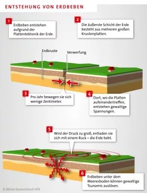
Floating on this fiery ocean are the tectonic plates. This is the crust we live on. The plates shift every year. They move apart. They collide. They slide past each other. This process is called plate tectonics.
Where plates meet, immense stress builds up. Edges rub together. They lock in place.
Eventually, that stress snaps. The energy releases in a violent jerk. The earth shakes.
Hypocenter vs. epicenter
All of this happens deep underground. The spot where the energy releases is the hypocenter. Scientists often call it the focus.
News reports usually mention a different term. They talk about the epicenter. This point lies directly above the hypocenter. It sits on the surface.
Damage is most severe around the epicenter. If the earthquake occurs under the ocean, the water displacement can create a tsunami. That is how a quake becomes a global disaster.
Why prediction remains impossible
You might ask why we cannot predict these events. The answer lies in the complexity of the crust. Stress accumulates over years or centuries. We do not know exactly when the rock will fail.
Current technology detects the waves after they start. It can issue warnings seconds before strong shaking arrives. But it cannot say when the next big one will happen. This limitation is dangerous. It leaves millions in vulnerable zones with little more than reinforced buildings to rely on.
Risk assessment in Germany
Many people wonder how likely strong quakes are in safe zones. What about Germany?
The risk here is significantly lower than in Morocco. Germany sits far from major tectonic plate boundaries. The plates are stable. Stress buildup is slow.
However, low risk does not mean zero risk. Historical records show minor quakes in the Rhine Rift Valley. These are usually harmless. A catastrophic event similar to Marocco is extremely unlikely. But the earth is dynamic. We must remain vigilant.
The tragedy in Morocco reminds us of the planet’s power. We build our cities. We assume the ground will hold. But the earth is always moving. It just takes time to show us.
The Aftermath Is Often Deadlier Than the Shake
Direct damage grabs the headlines. Buildings collapse. The ground fractures. Landslides bury entire neighborhoods. But the indirect consequences are what truly strip a region of its stability—and often its life expectancy.
Think about the chain reaction. When structures fall, people lose shelter. Roads crumble, cutting off supply lines for food. Water pipes rupture, mixing sewage with drinking supplies. Suddenly, you have a population without clean water, without safety, and without hygiene infrastructure. This is where the real killer enters the room. Disease spreads fast in these conditions. Cholera. Typhoid. Respiratory infections. The earthquake stops the shaking, but the devastation continues long after the tremors fade.
Why Do Some Places Bear the Brunt?
Geography isn’t random here. It’s tectonic destiny. Places that suffer the most from plate tectonics sit directly on continental plate boundaries. When plates collide, the edges are where the stress concentrates. These are the fault lines.
The Pacific Plate is the aggressive mover. It wraps around the “Ring of Fire.” It touches the West Coast of South America. It grinds against East Asia. It borders Australia. But it’s not just the Pacific Rim. The collision extends inland too.
High-Risk Zones You Need to Know
If you want to know which locations are most vulnerable, look for the collision zones. The Pacific Plate isn’t the only culprit. Continental drift has created hotspots across the globe.
- North America: The West Coast is a frequent target for strong quakes.
- Europe: Turkey, Italy, and Greece sit on complex fault intersections.
- Islands: Iceland faces constant geological pressure due to its position between tectonic plates.
These aren’t just theoretical risks. They are active, shifting boundaries. The further you move away from these edges, the safer you generally are. But for those living on the line? The risk is a daily reality.
“The indirect consequences regularly claim numerous lives.”
It raises the question: How do we prepare for a disaster that doesn’t just destroy buildings, but dismantles the very systems that keep society alive? The infrastructure is only half the battle. The response to the aftermath determines the death toll.
We know where the danger lies. We know what happens when the ground gives way. The hard part is building resilience in a world that is literally moving beneath our feet.
Hatten Sie in den letzten Tagen ein seltsames Wummern oder Geräusche aus dem Keller? Sie sind nicht allein. Pfungstadt in Südhessen erlebte gerade ein Beben der Stärke 3,1. Für Architekten vielleicht lächerlich klein. Für die Anwohner jedoch ein klarer Weckruf. Betten wackelten. Knallgeräusche hallten durch die Wände. Ein Nutzer auf Facebook beschrieb es treffend: Er dachte, ein Güterzug fahre direkt durch sein Schlafzimmer.
Solche Ereignisse sind hierzulande normal. Man muss nur wissen, wo man suchen muss.
Warum die Erde in Deutschland bebt
Deutschland liegt nicht direkt an einer Plattengrenze. Wir sind weit weg von der Action an den Rändern der tektonischen Platten. Doch die Bewegung stoppt nicht einfach an den Landesgrenzen. Die Kräfte, die die Alpen aufgefaltet haben, wirken hier indirekt weiter. Es ist der Druck, der entsteht, wenn die Afrikanische Platte auf die Eurasische Platte trifft.
Dieser Druck ist immens. Er sucht sich Wege nach Deutschland. Er sucht Schwachstellen.
Der Boden hier ist nicht fest wie Beton. Er ist durchzogen von alten Rissen und Verwerfungen. Der Oberrheingraben ist so eine klassische Zone. Wenn der fernöstliche Druck auf diesealten Strukturen trifft, gibt es nach. Deshalb bebt es bei uns. Nicht weil wir an der Kante stehen. Sondern weil wir in den Trümmern der Kollision stehen.
Die Stärke 3,1 in Pfungstadt fällt damit in den Bereich, der stark genug ist, um wahrgenommen zu werden. Doch er langt bei weitem nicht aus, um Gebäude zum Einsturz zu bringen. Wer sich für Erdbeben in Deutschland interessiert, sollte verstehen: Es sind meist Ausläufer. Abnutzungserscheinungen eines globalen Prozesses.
Die Richterskala erklärt
Wie quantifiziert man etwas, das sich nicht sehen lässt? Man misst die Erschütterung. Dafür nutzt man Seismometer. Die Geräte zeichnen die Wellen auf, die durch den Boden rasen. Die daraus resultierende Zahl wird oft als Richterskala bezeichnet.
Charles Francis Richter entwickelte sie in den 1930er Jahren. Ein US-amerikanischer Seismologe. Seine Skala reicht von Null bis Zehn. Die Logik ist brutal einfach. Jede ganze Zahl mehr bedeutet nicht doppelt so viel. Sondern zehnmal so stark.
- Stärke 0 bis 3: Sehr schwach. Oft unsichtbar. Gelegentlich von Menschen bemerkt, wenn sie genau hinhören.
- Stärke 3 bis 5: Spürbar. Gegenstände rutschen. Fenster klirren. Hier liegen die meisten Ereignisse in Deutschland.
- Stärke ab 5: Gefährlich. Häuser können Schaden nehmen. In seltenen Fällen einsturzgefährdet.
- Stärke 8 bis 9: Katastrophenlevel. Schäden erstrecken sich über Hunderte von Kilometern.
- Stärke 10+: Theoretisch möglich. Theoretisch verheerend über tausende Kilometer. Praktisch noch nie gemessen.
Wenn Sie also in Hessen ein Beben der Stärke 3,1 spüren, können Sie beruhigt sein. Es ist laut. Es ist beunruhigend. Es ist aber nicht zerstörerisch.
Die Minute, die Leben rettet
Können wir vorhersagen, wann es kracht? Nein. Nicht im klassischen Sinne.
Man kann keine exakte Vorhersage machen. „Am nächsten Dienstag um 14 Uhr bebt es.“ Das gibt es nicht. Was es gibt, ist eine Frühwarnung.
Seismografen in gefährdeten Regionen erkennen winzige Erschütterungen. Sie registrieren die Primärwellen. Diese Wellen sind schnell. Sie sind leise. Menschen spüren sie kaum. Aber sie kommen den Sekundärwellen voraus. Die Sekundärwellen sind die Zerstörer. Sie sind langsam. Sie sind laut. Sie knicken Brücken ein.
Zwischen diesen beiden Wellen liegen Sekunden. Manchmal eine ganze Minute.
Das ist wenig Zeit. Nicht genug, um eine Stadt zu evakuieren. Aber genug, um Maschinen zu stoppen. In Japan und Mexiko nutzen sie diese Lücke.
– Züge werden automatisch gebremst.
– Gasleitungen schließen sich.
– Ampeln springen auf Rot.
Warum? Um Kollisionen zu verhindern. Um Brände zu minimieren. Um die typischen Todesursachen während eines Bebens zu reduzieren. Es ist kein Schutz vor der Wucht. Sondern ein Schutz vor den Folgen.
Tierische Vorboten
Gibt es eine Methode, die früher warnt? Stunden? Tage?
Wissenschaftler forschen daran. Die Methode klingt fast biblisch. Wir hören auf Tiere.
Beobachtungen zeigen, dass Ziegen, Vögel und Kröten ihr Verhalten ändern. Bevor die Erde bebt, suchen sie höheres Gelände. Sie werden unruhig. Sie fliehen. Die Frage ist nur: Wie nutzt man das wissenschaftlich?
Die Mechanismen dahinter sind noch unklar. Vielleicht hören sie Infraschall. Vielleicht spüren sie elektrische Felder. Noch steckt die Forschung in den Kinderschuhen. Man kann sich nicht blind auf das Verhalten von Ziegen verlassen, um Evakuierungsbefehle auszugeben.
Doch die Tatsache bleibt: Die Natur warnt oft, bevor die Technik es schafft.