Heat rises. Water expands. Satellites notice.
A massive climate shift is brewing beneath the Pacific waves. We aren’t guessing about it anymore. NASA and its partners see the ocean swelling right before their eyes.
El Niño made its official comeback in June 2025. Wait — actually June 2026. Time moves fast or slow depending on how much coffee you’ve had. NOAA confirmed the event on June 1st… no, June 11. After sea temperatures sat at least half a degree Celsius warmer than normal for months. That’s the technical threshold. But space agencies saw trouble brewing weeks before that date dropped.
Seeing Heat From High Altitudes
The signal isn’t just warm air hitting your skin on a beach walk. It’s deeper.
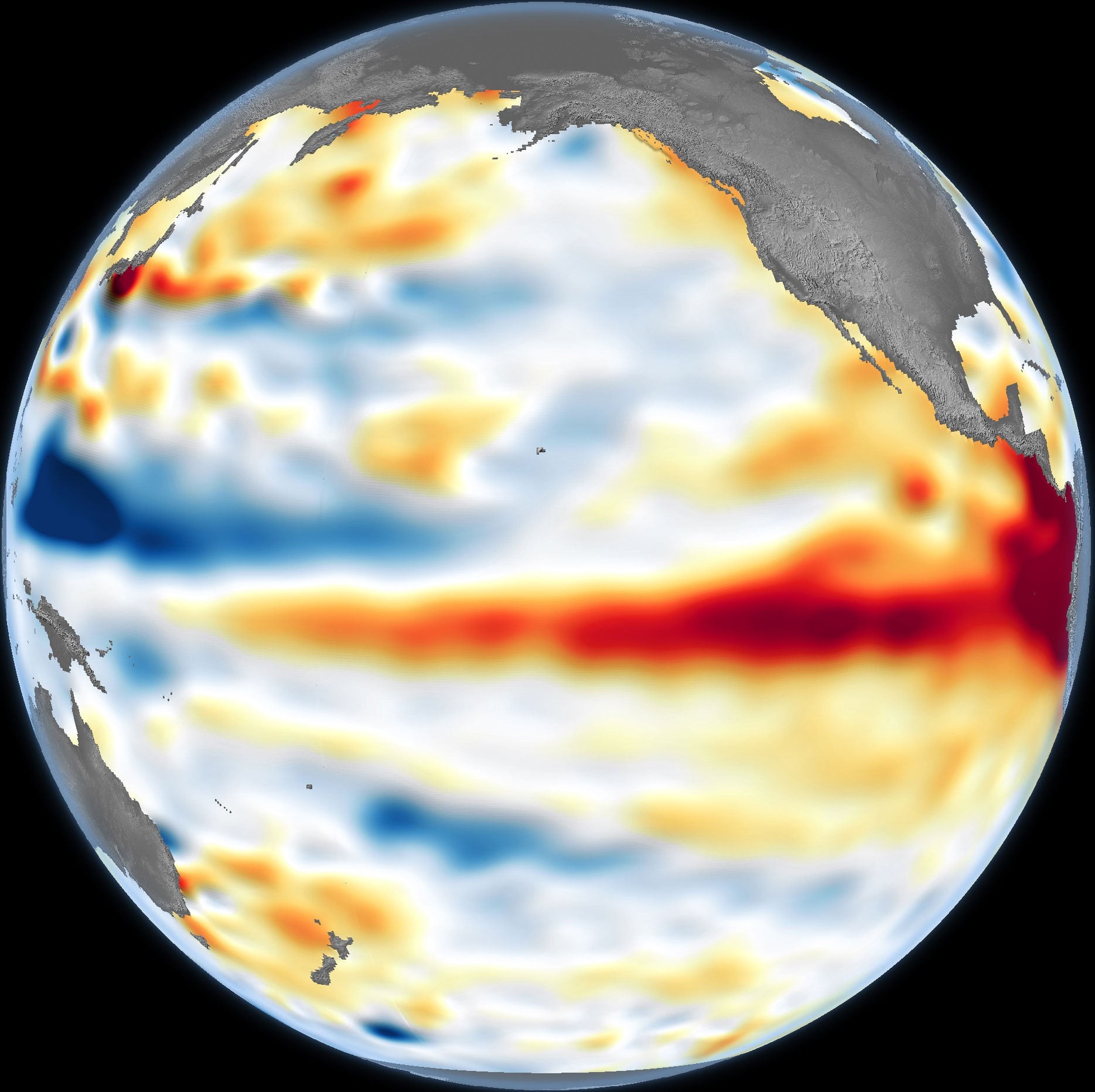
Sentinel-6 Michael Freilich stares down from orbit. This NASA-Eur space team joint effort tracks the physical height of the ocean. Why? Warm water takes up more room than cold water. It’s basic physics. When you pile up heat in the central Pacific, the sea surface literally lifts up.
Red on the map. Elevated levels.
Blue? Lower. Near-normal stays white.
Scientists stripped away the seasonal noise and the long-term tide changes caused by global warming itself. They wanted to see the raw pulse of the storm. What remained was clear. The water was getting taller.
The Kelvin Wave Shuffle
This didn’t happen overnight. It’s a slow build.
Spring 2026 saw big pulses of warmth racing eastward across the equator. Kelvin waves. Named after a physicist, not a hotel chain. These waves act as early warning lights for El Niño formation. They usually pop up when the trade winds take a break. Or worse, when they reverse.
Normally those winds push warm water to the western side. They pile it up in Asia. When the breeze stops? That heat slides back. Toward the Americas. Like a tide going out. Only hotter.
A Deeper Blanket
Here’s why this specific measurement matters so much.
A thin skin of warm surface water can evaporate or get stirred up by storms in a day. But these Kelvin waves drove heat down. They pushed the thermocline—the boundary between warm shallow water and deep cold stuff—farther underwater.
Think of it like putting a heavy wool blanket on top of the ocean. A thick one. Hard to shake off. Hard to disrupt.
This deep reservoir feeds the El Niño beast for longer. It gives it stamina. The ocean is basically capping itself in warmth. Which means cooler water can’t easily rise from below along the Pacific coast of South America. Upwelling gets suppressed. The cycle locks in.
1997 Calling…
So, are we doomed to repeat history?
Séverine Fournier watches the data closely. She’s a researcher at JPL and works directly on Sentinel-6. On June 8th, the western Pacific looked terrifyingly like the summer of 1997. Remember that year? One of the most violent El Niño events ever recorded.
“For now, it looks like a big one.”
But don’t panic just yet. 2026 isn’t 1997 on replay. The east was lagging. Fewer Kelvin waves had made it to the American side by June compared to thirty years ago. It was still catching up.
More heat waves are on the move though. Heading east. Still gathering strength.
Will 2026 rival the historic monster from ’97? Nobody knows. Maybe. Probably. The ocean and the atmosphere are about to start arguing. And the weather will suffer.
Fournier said it herself: More so than I would have said a week ago.
We’ll need more weeks of staring at the stars. And at the swelling water below them. To find out where this is headed.